MORE ABOUT THE AQUIFER:
Formation of the Aquifer
The Barnes Aquifer is made up of sediment deposited by streams flowing off the ice of melting glaciers that covered our region numerous times during the last 2 million years (Pleistocene Epoch). The last ice sheet approximately 15,000 years ago was centered at Hudson Bay, Canada, and extended south to Long Island, New York.
Melting of the continental glaciers produced huge quantities of water and sediment. Meltwater streams were effective in sorting the sediment eroded by the ice. The silt and clay size material was transported into lakes or carried all the way to the sea while the sand and gravels were deposited within the channels and floodplains of the meltwater streams or in deltas at the margins of glacial lakes. When the glaciers left the area the meltwater streams dried up and the sorted sands and gravels were left behind.
Lake Hitchcock
As the ice front retreated northward up the Connecticut River Valley, a large glacial lake formed. This lake was dammed by glacial sediment filling the valley near New Britain, Connecticut. At its maximum, this lake, now known as Lake Hitchcock, extended from central Connecticut northward to St. Johnsbury in Vermont. Meltwater streams emerging from the ice at the snout of the glacier deposited sands and gravels into the lake in the form of ice-contact deltas. The size of these deltas was controlled by the size of the meltwater stream and the amount of time the ice front remained at any one place.
Formation of the Aquifer
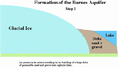
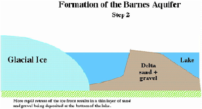
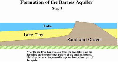
The ice front paused or retreated very slowly as it moved across the Westfield, West Holyoke, Southampton and southern Easthampton area. This allowed the building of a large delta whose sediments form much of the Barnes Aquifer (Stage 1). The ice front began to retreat much more rapidly as it moved north of the Plains area of Easthampton. During the more rapid retreat of the ice, meltwater streams emerging from the ice into the lake did not have time to build a delta. Instead, sands and gravels were deposited as a relatively thin apron at the bottom of the lake Aquifer (Stage 2). After the ice front retreated north of Easthampton, these sands and gravels were buried by glacial lake sediments composed of alternating bands of silty sand and clay (varves). These lake sediments extend up the sides but not over the tops of the deltas Aquifer (Stage 3). Eventually the sediments that dammed Lake Hitchcock were eroded and the lake drained exposing the sediments that make up the Barnes Aquifer.
The Barnes Aquifer is composed of well-sorted, sands and gravels that were deposited by meltwater streams flowing into a glacial lake. The coarse grain-size and excellent sorting of the sediment accounts for its having a high permeability.